Saturday was the start of our warm up here in the Caroina's and Sunday is looking to be even warmer. While Monday we may reach the low to mid 60s here in central North Carolina Monday will have a weak dry front move through only bringing temps into the mid to upper 50s Tuesday then Wed-Thursday should see another bigger warm up and by Firday we should be back in the mid to upper 60s and same if not 70 by Saturday,
Heres both the GFS and EC ensembles for Friday morning.
Both shows a big warm up with 850mb temps close to 10/12C and that would translate to mid tp upper 60s and possible low 70s.
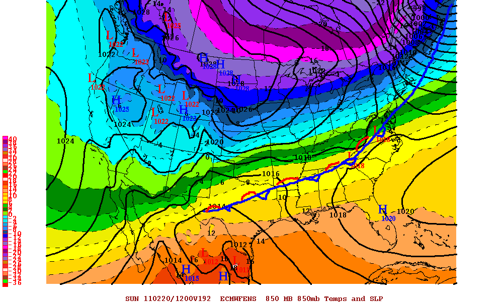
Heres the ECENS for Sunday morning showing a stalled cold front around the Carolina's bringing some possible rain.
But the ECMWF OP is leaning more towards Monday on this stalled front.
Saturday, February 12, 2011
Thursday, February 10, 2011
Next week forecast. Feb14-18th.
Warmth will be the main story around here next week with the warm up starting this weekend. Saturday should see temps in the low 50s and Sunday we will probably get close to hitting 60. On Monday there will be a weak front move through cooling us down only a few degrees on Tuesday.
In blue- Upper level energy that will bring a weak cold front by.
In red the upper level ridge that will bring in the warmth by next week.
Tuesday/Wednesday temps will be in the mid to upper 50s and Thursday temps should be in the low 60s with mid 60s by Friday. But Next Saturday Feb 19th get ready for this as temps (by the ECMWF) should hit 70.
It may be hard to see but click to enlarge. Also the long range models show a +EPO and that means a ridge in the eastern Pacific a trough in the west and ridging in the SE US, and if this were to hold true then I dont see a big cold shot for a while but minor cool downs will come but I think the true La Nina pattern may just hold at least till the end of the month.
One more thing here is the snow fall totals across NC with eastern NC taking the cake as I forecasted.
In blue- Upper level energy that will bring a weak cold front by.
In red the upper level ridge that will bring in the warmth by next week.
Tuesday/Wednesday temps will be in the mid to upper 50s and Thursday temps should be in the low 60s with mid 60s by Friday. But Next Saturday Feb 19th get ready for this as temps (by the ECMWF) should hit 70.
It may be hard to see but click to enlarge. Also the long range models show a +EPO and that means a ridge in the eastern Pacific a trough in the west and ridging in the SE US, and if this were to hold true then I dont see a big cold shot for a while but minor cool downs will come but I think the true La Nina pattern may just hold at least till the end of the month.
One more thing here is the snow fall totals across NC with eastern NC taking the cake as I forecasted.
Wednesday, February 9, 2011
Wednesday evening snow forecast update.
Heres the latest from the NWS watch/warnings and most of eastern NC is either in a winter weather advisory or winter storm warning. Also areas just SW of the Triad, Charlotte is also in winter weather advisory. Heres the RUC with the liquid accumulated precip and I have in white the area in NE NC that could to anywhere from 2-5in of snow by tomorrow morning.
Also the watch/warning map
The GFS also picks up on some possible modest snow amounts in north east NC.
As for us just east of the mountains to just west of the Triangle we look to get less than an inch, (if your lucky you may get up to 1'') so for the Triad area this will be a small to none event as the moisture really drys out coming over the Mnts and the surface low weakens, But the low off the coast will gain strength and crank up the precip out there so for now if your around the Triad area anywhere from north of Charlotte and west of the Triangle were going to miss out on this for the most part, ALTHOUGH I cant rule out a small area getting 1-2in but mostly a dusting to 1/2in at beast.
Also the watch/warning map
The GFS also picks up on some possible modest snow amounts in north east NC.
As for us just east of the mountains to just west of the Triangle we look to get less than an inch, (if your lucky you may get up to 1'') so for the Triad area this will be a small to none event as the moisture really drys out coming over the Mnts and the surface low weakens, But the low off the coast will gain strength and crank up the precip out there so for now if your around the Triad area anywhere from north of Charlotte and west of the Triangle were going to miss out on this for the most part, ALTHOUGH I cant rule out a small area getting 1-2in but mostly a dusting to 1/2in at beast.
Subscribe to:
Posts (Atom)