Wednesday, October 3, 2012

Warm for the rest of the week, turning much cooler by early next week!

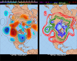
Last few days have felt warm and a bit humid (almost late August than early October) while the air will dry in the coming days (though warmth will stay around with temps in the low 80s) By this weekend will a large change in temperatures are forecast. Looking at our forecast model (GFS/ US model) 
Mild temps out ahead of the next front that will really knock temps back.

Both models are valid Monday Oct 8th. All thanks to a large trough setting up over eastern North America.
There are still signs from the longer range more reliable European model as well for cooler temps in the east
Beyond this I expect a warmer/mild pattern as we head into later October with Halloween possibly being mild for the South East? we'll see.


Monday, October 1, 2012

Chance of severe storms later (low chance)

Most of NC is locked in a cool wedge air mass today as a weak surface high over the Great Lakes ridges down the eastern side of the Mountains and a storm systems moves in from the west/south west. 
With that comes clouds and rain 
Now watching things around southern portions of NC for later tonight as the warm front moves northward overnight, with this comes the chance for storms as more unstable airs moves in 
though the warm front may not make much progress into North Carolina tonight and may move north by early tomorrow as seen in this HPC forecast image overnight (2am) 
Though the chance is low, any storms that can develop has a good chance of rotation and with the cloud bases close enough an isolated tornado is possible (but again low chance) 


Sunday, September 16, 2012

Heavy rain event on the way for for state (NC)

Large scale rain event is taking shape across the southern half of the country. We see this on the Surface map (9:30pm EDT) 

Looking at water vapor satellite an upper low is seen over TX (outlined in red) and also in red on the top of the image is the northern stream energy that will give a kick to the southern stream over TX.
Taking a look at Monday morning we can see the northern and southern jet stream coming close to what looks like a phasing of the two jet streams. 
This should help develop a surface Low over the Gulf states-
Easterly winds here in central NC will keep transporting moisture off the Atlantic and keep things damp in some areas across the state before the heavier rains move in! 5day rainfall forecast