Some severe weather is in store for the southern central US in the next 12-36hrs, heres the Storm Prediction Center outlook for tomorrow Thurs.
A mod risk, when you see that in early spring/late winter you know it means business. But lets focus on our area here in central North Carolina. Tomorrow should be a mostly cloudy day with some rain showers possible later in the day with highs in the mid to upper 50. Overnight a warm front should surge northward bringing much more warmth and moisture with it into much of NC east of the mounts. Heres the NAM forecast model for Friday morning, with the 10C line at 5000ft meaning a lot of warmth coming in.
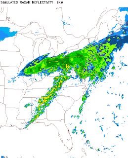
Also take a look at the NAM simulated radar forecast for Friday morning, see that line of storms over the SE that could form into a squall line, meaning a line of fast moving showers and embedded thunderstorms with possible tornadoes as well.
Heres a look at a higher Res model called the NMM WRF.
A bit better view of the line of showers and storms. Another thing to look at is the Surface to 500mb(18,000ft) wind shear and shear of 40-50knts or greater indicates winds are favorable for supercell storms(those are the ones that produce tornadoes)
So while I dont expect the severe weather threat to be nearly as high as west of us, I cant rule out a few severe storms here as the main line moves through with strong winds(even after the storms move by the wind will kick up most of the day)or even a tornado. Also even by after noon there could be a few pop up showers and storms as the sounding below shows moisture in the lowest 4-3000ft and some aftnoon heating.
That image above is for 4pm Friday aftnoon showing a few storms still possible as the cold font will not fuly sweep through till later that evening.
Wednesday, February 23, 2011
Monday, February 21, 2011
Cooler weather for the next few days, followed by some rain possible? by weekends
Today was another nice warm day, typical of April than Late Feb but Ill take it. For Tuesday and Wednesday we'll see highs back in the mid to upper 50s so still a few degrees above avg so not bad. But as we head into Thursday we should see a Cold Air Damming event (minor one) Thurs morning but by Thursday evening should see temps and moisture surge northward this way.
Possibly causing some light rain overnight Thursday into Friday morn. By Friday afternoon we should see the cold front makes its way through, although it does not look like severe wx for us there could be a rumble of thunder,
EC
But the best upper level support (on the EC) goes north leaving us with just a soaking rain, the GFS on the other hand being farther south with this Low could spell severe wx for eastern NC but we'll see, and I have a feeling the EC may be right.
Saturday, February 19, 2011
A look back at the Jet stream position and the effects on our weather(also on my Liveweatherblogs.com page)
Got to love the Sub Tropical Jet
If your a warm weather lover like myself, heres a look back at the first part of winter from Dec1st 2010 to Jan31st 2011.
First the Jet stream, and you can see the Polar jet.
Mean position of the jet stream during the first 2 months of winter.
Next is the mean surface temps, and one can note the COLD over the East South East US.
Really cold stuff for us southerners. But the first 2 weeks of Feb have overall turned out warmer heres the Jet stream as of Feb 1 to Feb 16 and we can see the STJ kick in as La Nina makes her self known.
And along with that comes warmer mean temps as noted below,
Ahhh, we can see warmer mean surface temps and thats what I like to see, but not to worry for my firends up north winter is coming back for you!
Subscribe to:
Posts (Atom)


