Some severe weather is in store for the southern central US in the next 12-36hrs, heres the Storm Prediction Center outlook for tomorrow Thurs.
A mod risk, when you see that in early spring/late winter you know it means business. But lets focus on our area here in central North Carolina. Tomorrow should be a mostly cloudy day with some rain showers possible later in the day with highs in the mid to upper 50. Overnight a warm front should surge northward bringing much more warmth and moisture with it into much of NC east of the mounts. Heres the NAM forecast model for Friday morning, with the 10C line at 5000ft meaning a lot of warmth coming in.
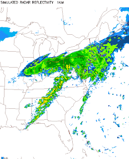
Also take a look at the NAM simulated radar forecast for Friday morning, see that line of storms over the SE that could form into a squall line, meaning a line of fast moving showers and embedded thunderstorms with possible tornadoes as well.
Heres a look at a higher Res model called the NMM WRF.
A bit better view of the line of showers and storms. Another thing to look at is the Surface to 500mb(18,000ft) wind shear and shear of 40-50knts or greater indicates winds are favorable for supercell storms(those are the ones that produce tornadoes)
So while I dont expect the severe weather threat to be nearly as high as west of us, I cant rule out a few severe storms here as the main line moves through with strong winds(even after the storms move by the wind will kick up most of the day)or even a tornado. Also even by after noon there could be a few pop up showers and storms as the sounding below shows moisture in the lowest 4-3000ft and some aftnoon heating.
That image above is for 4pm Friday aftnoon showing a few storms still possible as the cold font will not fuly sweep through till later that evening.


No comments:
Post a Comment