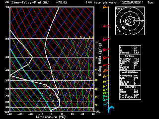
Well for a while now the models have been hinting at some possible wintry weather early next week around the Mon-Tuesday time frame. But I dont think this will be an all snow event its looking more likely that it will be a mixed event with snow,freezing rain, then rain. Here are some forecast Skew-T charts(shows the atmospheric profile) showing snow to start then to freezing rain then rain first up some images from the ECMWF model (from Accuweather Pro.com)
this temp profile shows mostly all snow to start the event along with the GFS model below.(same time Monday evening)
same thing mostly snow. But as we go on 12 hours later to Tuesday morning both EC and GFS show more freezing rain with a 850mb warm front but surface temps stay below freezing.
GFS
And later forecast soundings show surface temps warming to just above freezing, BUT this is still days out and a strong high in the NE in a good area to keep some low level cold air in we'll see if we make it above the 32 mark.
EC model showing Tuesday morning setup.
Thats all for now Ill have more as this possible event draws closer.


No comments:
Post a Comment